
|
|
Palenque Sightseeing |
| Home Page | About Us | city Description | Hotels | Villa, B& B's | Restaurants | Golf + Activities | Sightseeing | Destination Services | RV/Trailer Parks & Hostels | Travel Value Packages | Airlines | Other Cities in Mexico | What's New | General Info | State Map | Regional Map | Country Map | Books + CD's | Blog |
| Nearby Cities -> | San Cristobal de las Casas | Villahermosa |
Local Sights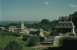
Mayan Ruins at Palenque Description One of the principal Mayan Ceremonial cities similar in magnitude and importance to Tikal and Chichen Itza. Magnificent setting where the jungle meets the mountains. Nearby Sights 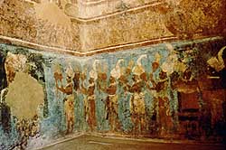
Frescoes at Bonampak Directions South on secondary road to Frontera Echeverria - approximately 100 miles and follow signs to Bonampak. Palenque Description Small Mayan ceremonial center discovered in the 1940's famous for its frescoes depicting life in the area around 600 A.D. 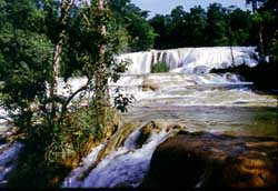
Agua Azul Waterfalls Directions Approximately 30 miles south of Palenque in the Sierra de Chiapas on the road to Ocosingo/San Cristobal de las Casas. Description Spectacular waterfalls and rivers in a natural preserve. Yaxchilan Mayan Ruins Directions Twenty miles north of Bonampak on the Usumacinta River Description Large Maya site deep in the Lacandon Jungle on the banks of the Usumacinta River. Tall temples carved with illustrations of rulers and ceremonies. Accessible only by boat. |
| Home Page | About Us | City Description | Hotels | Villa, B& B's | Restaurants | Golf + Activities | Sightseeing | Destination Services | RV/Trailer Parks & Hostels | Travel Value Packages | Airlines | Other Cities in Mexico | What's New | General Info | State Map | Regional Map | Country Map | Books + CD's | Blog |
|
Based on information contained in the Mexico Travel Database on October 31, 2011 |
| Powered by Dataperfect |